Your web browser (Internet Explorer) is out of date. Some things will not look right and things might not work properly. Please download an up-to-date and free browser from here.
5:25am, 29th May
Home > News > Cyclone Gabrielle strengthening as it sl...
Cyclone Gabrielle strengthening as it slowly passes Great Barrier Island (20+ maps)
13/02/2023 11:15am
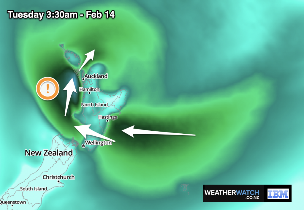
12:15am Tuesday NZDT — Cyclone Gabrielle’s movement has slowed to an absolute crawl near Great Barrier Island.
The longer the cyclone takes to move through, the higher the rainfall totals will go – and increased wind damage.
As we head towards sunrise the tracking of the centre of the storm will begin to gradually speed back up again as it shifts from a southerly track to a south-easterly track again. This will take it towards East Cape, arriving there likely mid-Tuesday afternoon, based on modelling on Monday night.
Gabrielle is expected to continue deepening (air pressure wise) until around dawn (5am – 7am roughly). This means severe weather is expanding and strengthening over much of the North Island as we go into Tuesday.
Heavy rain is lingering in Northland and Auckland this morning – pushing totals up. Severe gales are also going to continue on for many in these two regions (but in some locations they may ease back a little, as the winds tilt from southerly to south-south-westerly. These winds are likely to be pulled back in from the Tasman Sea as the storm slowly moves away from the top of the North Island over Tuesday meaning western areas in particular maybe quite exposed to damaging gusts and power outages.
That tracking will also mean severe gales are expanding southwards into the lower North Island and upper South Island, taking Gabrielle’s rain bands there too.
This is a serious ongoing event which will last at least another 24 to 48 hours across many regions of New Zealand.
Stay up to date with MetService warnings and WeatherWatch.co.nz. Also hourly weather data, totals and graphs at RuralWeather.co.nz.
⚠️12am: Water vapour satellite imagery past 6hrs shows bands of heavy rain erupting out from the southern & western sides of #Gabrielle tonight.
— WeatherWatch.co.nz (@WeatherWatchNZ) February 13, 2023
Slower the movement of Gabrielle = the higher the likelihood of increased rainfall totals, #slips & #flooding (Animation: Weatherzone) pic.twitter.com/vkgpaWW3HT
🌀10:30pm: Current position of #CycloneGabrielle, which is now strengthening a further 6 to 10 hours.
— WeatherWatch.co.nz (@WeatherWatchNZ) February 13, 2023
The centre will slowly start to drift towards East Cape, arriving there Tuesday afternoon, likely mid-afternoon.
Low air pressure estimates (dawn Tue):
🇦🇺961 hPa
🇺🇸961
🇬🇧964 pic.twitter.com/lPlHHJNmJC
The fractured towering clouds surrounding #CycloneGabrielle's centre produced big shadows at sunset this evening (& heavy rain).
— WeatherWatch.co.nz (@WeatherWatchNZ) February 13, 2023
The storm's centre is powering up further overnight, to the east of #GreatBarrierIsland. Air pressure will likely drop at the centre until about dawn. pic.twitter.com/0aXJcB35iX
The lower the air pressure the more powerful and severe the storm is. It makes the storm more unstable and will see wind and rain spread further out and intensify. The fact this intensification is going to occur as Gabrielle approaches the Auckland and Coromandel Peninsula regions makes it more problematic and complicated.
New Zealand’s mountains and ranges also play a big role. “In the United States when storms come off the Atlantic they don’t have to contend with large mountain ranges as much of southern and south eastern US is quite low down, making severe weather more evenly spread. But in NZ our mountains and ranges alter the weather, producing pockets of calm whilst other areas are made much more intense by the terrain. It adds another layer of complication to forecasts” says head forecaster Philip Duncan. “This is the reason why some have lost power and others may be wondering where the worst winds are”.
Gabrielle is a large storm, WeatherWatch.co.nz says it’s at least two to three times the size of New Zealand and is yet to properly arrive. That’s why across Monday night and Tuesday we’ll be seeing the peak of this storm moving through, with conditions easing around Thursday and Friday.
Latest tracking shows the centre of Gabrielle to move over, or very near, Great Barrier Island in the Auckland region and northern Coromandel Peninsula tonight and then drift over the Bay of Plenty (sea area, not land) towards East Cape. This placement may help Auckland reduce storm surge risks a little – but also means windier weather may linger for longer. However the S-SE wind flow is often kinder to Auckland city than a NE wind, thanks to the specific placement of Gabrielle so far. This is helping Auckland avoid having even worse winds.
Auckland gets a lot of attention due to the size of the population – and the recent severe weather – but many regions in the east will have wetter weather, with over 500mm possible if Gabrielle slows down. Stronger winds will also likely occur to the east of many of the main ranges of the North Island.
It’s fair to say that the worst is yet to come for many parts of NZ as Cyclone Gabrielle finally moves in tonight – and strengthens further with severe weather spreading down NZ and towards the upper South Island.
🌀As #Gabrielle deepens (air pressure) overnight, severe gales will strengthen. The storm is a bit lopsided, but you can see winds ramping up in the next 6 hrs.
— WeatherWatch.co.nz (@WeatherWatchNZ) February 13, 2023
SSW Gales will be especially strong along the eastern Tasman Sea & gradually pull into the western Nth Island on Tue. pic.twitter.com/8GGM1dFuwC
Air pressure @AKL_Airport is down to 977hPa now.
— WeatherWatch.co.nz (@WeatherWatchNZ) February 13, 2023
👂🍾 (ear pop!)
If you're a weather enthusiast – view our forecast barometric pressure in the Daily Data tab halfway down the page here: https://t.co/HBgbFSxQ1H pic.twitter.com/OuMen7OlaC
Fun times @WeatherWatchNZ @GulfHauraki 20hPa drop in 24 hours and still going pic.twitter.com/AqBt7DTaK8
— zkav8or 🔑🟤 (@JonathanPowles) February 13, 2023
Cyclone Gabrielle is tracking southwards now and lies roughly 100km to the north east of Great Barrier Island.
— WeatherWatch.co.nz (@WeatherWatchNZ) February 13, 2023
Being the centre, this represents the middle mark of the storm, so there's still the other half to move through. That means 48 hours before it clears the North Island. pic.twitter.com/nw7QASrVWm
The size of Cyclone Gabrielle is clear in this video.
— MetService (@MetService) February 13, 2023
Since noon, we're recorded gusts of 150 – 160 km/h, and some stations in Gisborne have recorded rain rates of 15 – 30mm in a single hour. pic.twitter.com/1dZ1A4dxEU
🌀The most powerful winds at the moment are in the area with this shape… #CycloneGabrielle https://t.co/gb7E1quzdb pic.twitter.com/4ejRNfSM86
— WeatherWatch.co.nz (@WeatherWatchNZ) February 13, 2023
Tweet 2/2 images supplied credit Beverley Watson @WeatherWatchNZ
— Matty Matt (@MattDyer01) February 13, 2023
Other media can not use unless permission given from myself pic.twitter.com/ozETjx90va
@WeatherWatchNZ received images of Ruakaka beach and Marsden Cove Marina… photos/widro supplied credit Beverley Watson
— Matty Matt (@MattDyer01) February 13, 2023
Other media can not use unless permission given from myself pic.twitter.com/RIpqx60IG3
That's quite the hairdo the North Island has got going on today… 💇♀️
— WeatherWatch.co.nz (@WeatherWatchNZ) February 13, 2023
📡 Track heavy rain from Cyclone Gabrielle live on @MetService Rain Radar as it sets in for the night –https://t.co/sZ6VGec556#Slips #Flooding
⚠️Avoid travel. Stay up to date with your local #CivilDefence. pic.twitter.com/tsIy544Q4L
Cyclone Gabrielle is forecast to bring large waves to some coasts for the next few days. Check out the significant wave height forecast for NZ here https://t.co/y7sa5Ofj1O ^PL pic.twitter.com/HGVYTGJoZt
— MetService (@MetService) February 12, 2023
📽️🌪️Latest wind gust animation for the next 48 hours ahead. This could still move around a little depending on #CycloneGabrielle's precise tracking.
— WeatherWatch.co.nz (@WeatherWatchNZ) February 12, 2023
⚠️View the latest official @MetService wind warnings here: https://t.co/7xoHnjeNiw pic.twitter.com/HGq1nQoOCD
📽️☔️Latest 48 rain accumulation map. This is a great general guide at showing you which areas are most at risk from heavy rain in the coming two days.
— WeatherWatch.co.nz (@WeatherWatchNZ) February 12, 2023
⚠️Keep up to date with the latest @MetService rain warnings for peak totals in your area. https://t.co/7xoHnjeNiw pic.twitter.com/qFk0ZLjHdO
Winds will swing SE↖️ to S⬆️ to SW↗️ for the upper North Island today & tonight as Cyclone Gabrielle tracks down the eastern coastline of Northland.
— WeatherWatch.co.nz (@WeatherWatchNZ) February 12, 2023
This means the wind direction is continually shifting – why it's eased back for some, intensifying for others.
Many moving parts! pic.twitter.com/cD72fu4REp
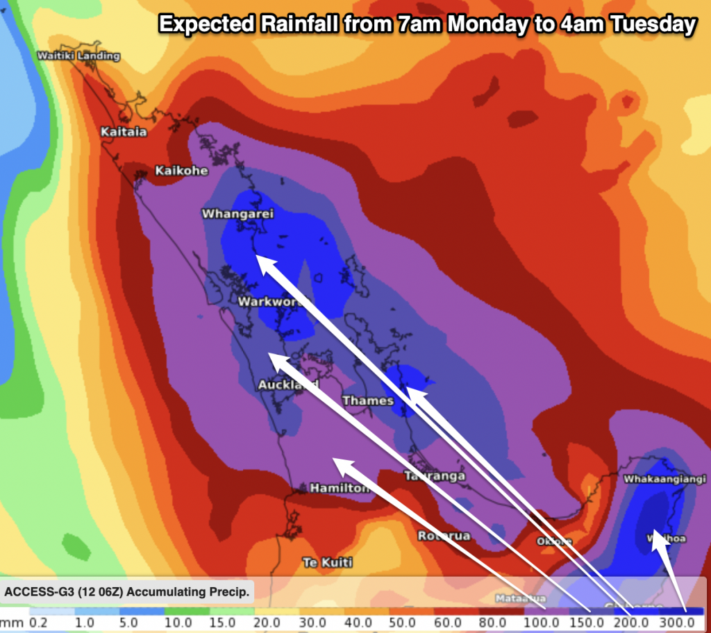
🌀4⃣weather models showing the lowest air pressure expected from #CycloneGabrielle, before dawn Tuesday.
— WeatherWatch.co.nz (@WeatherWatchNZ) February 12, 2023
The slightly further eastern track for Auckland may reduce storm surge, but may mean stronger southerlies continue longer.
All potentially record breaking low air pressure⬇️ pic.twitter.com/lxIrXGIsjR
🚨6:25am: Despite severe weather across many regions for the past 24 hours, Cyclone Gabrielle is still located north of NZ.
— WeatherWatch.co.nz (@WeatherWatchNZ) February 12, 2023
⚠️The storm is tracking into the upper North Island today – and tonight it will intensify as it approaches Northland, Auckland & Coromandel Peninsula. pic.twitter.com/qCaDGUoeSj
⚠️Important:
— WeatherWatch.co.nz (@WeatherWatchNZ) February 12, 2023
1) Cyclone Gabrielle's air pressure will drop next 24 hours, making the storm more intense. The Aussie model is picking 957hPa near Great Barrier Island. Other models 960 – 965hPa range.
2) Currently 970hPa, north of NZ
3) Closest to Auckland/Coromandel early Tue. pic.twitter.com/72sqUUa06x
🌀🌪️NZ's mountains & ranges (terrain) interrupt the airflow. That's why, despite widespread gales in the upper North Island, not all areas have wind (or rain).
— WeatherWatch.co.nz (@WeatherWatchNZ) February 12, 2023
⚠️Direction of wind will continually shift next 48hrs, exposing #new areas to damaging gusts – also sheltering others. pic.twitter.com/PW4tNnwtTf
Comments
Latest Video
Wednesday Newsfeed: Cold, wet & gales in the north but high pressure & milder winds coming
Wednesday is a colder and wetter day for northern NZ as a surge of gales and rain/showers moves through. The…
Related Articles
Wednesday Newsfeed: Cold, wet & gales in the north but high pressure & milder winds coming
Wednesday is a colder and wetter day for northern NZ as a surge of gales and rain/showers moves through. The…
VIDEO: Gales & cold rain, ahead of milder winds & high pressure
Wednesday is a colder, wetter and windier day across large parts of NZ as low pressure deepens off our east…
Tuesday Newsfeed: Windy, wetter & colder couple days ahead – but sunshine too
High pressure near Australia is encouraging colder winds into NZ… but by Saturday that high will be anchored near The…
Navigation
© 2023 WeatherWatch Services Ltd


Add new comment
Jaco Du Preez on 13/02/2023 12:05pm
Realy appreciate the fantastic work that you guys are doing. The frequent updates are very informative and provides a measure of comfort in knowing what to expect.
Reply
Felyne on 13/02/2023 9:47am
IABLAN25 is reading 967.83 on ruralweather, is that right (it’s currently 10:47pm)
Reply
WW Forecast Team on 13/02/2023 10:04am
Not sure sorry – a lot of those private ones aren’t perfect, it sounds a bit low (Auckland is 976hPa as 11pm)
– WW
Reply