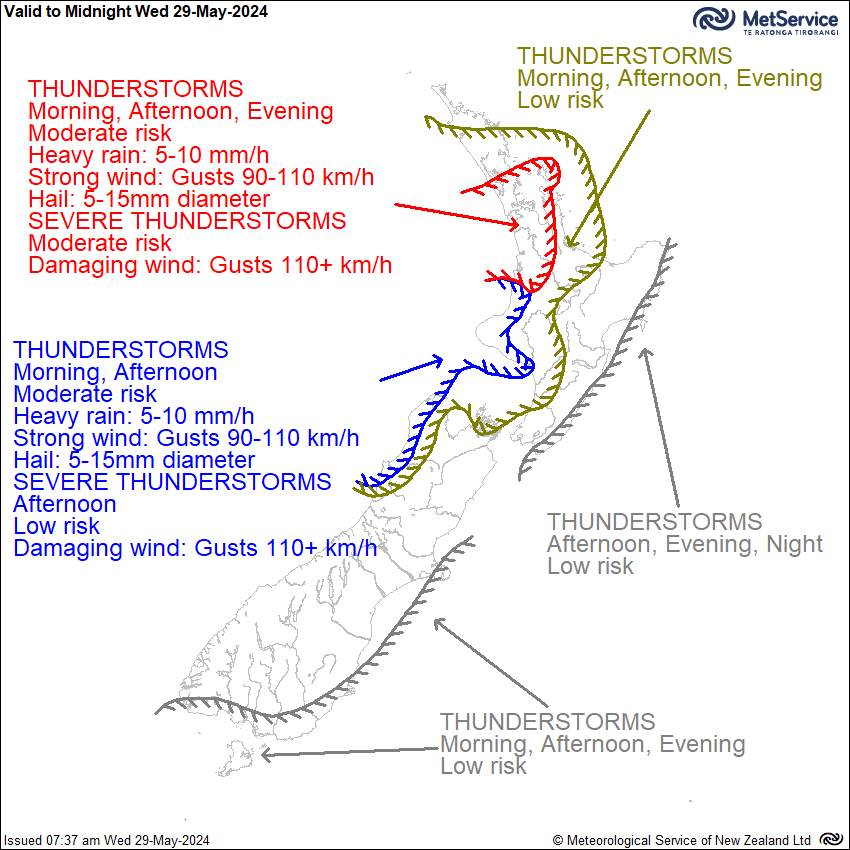
Thunderstorm Outlook
Issued at 7:37am 29/05/2024
Valid from 7:37am 29/05/2024 to Midnight 29/05/2024
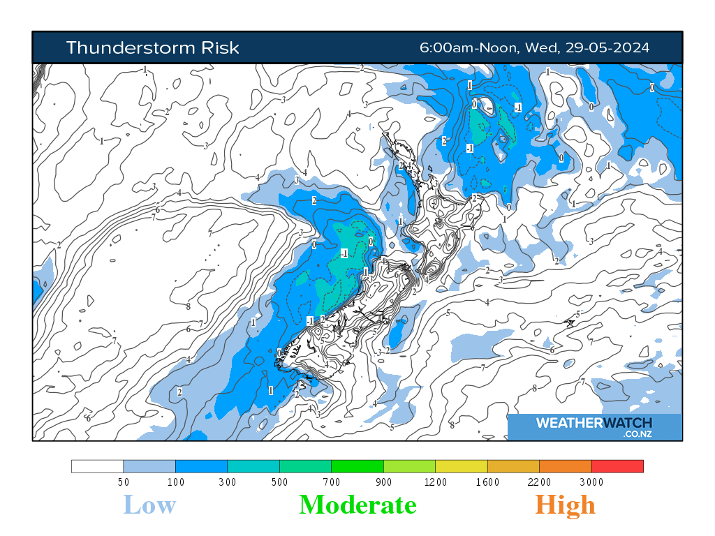
An unstable southwest to southerly flow covers New Zealand today, strengthening from late morning. Wind Watches and Warnings for severe gales about parts of the North Island and southern South Island are in force along with a Severe Thunderstorm Watch. See https://www.metservice.com/warnings/home for more detail. Over the North Island, there is a moderate risk of thunderstorms about western areas from Auckland to Whanganui (including the Hauraki Gulf and Great Barrier Island), especially late morning and afternoon, but this risk reduces to low in the evening. A broader low risk covers other areas from Northland to western Bay of Plenty and Horowhenua this morning, afternoon and evening, and also about eastern coastal areas from Wairarapa to Gisborne/Tairawhiti from afternoon as indicated on the chart. The thunderstorms in western areas will be embedded within a very strong southwest flow, and will bring brief heavy rain and hail. Very squally wind gusts can be also expected with the thunderstorms, mainly in the 90-110 km/h range. However there is a moderate risk of SEVERE THUNDERSTORMS over Auckland, Waikato and western Coromandel Peninsula, where damaging wind gusts in excess of 110 km/h are possible. A low risk of SEVERE THUNDERSTORMS with damaging wind gusts in excess of 110 km/h extends further south into Waitomo, Taranaki, Whanganui, western Tasman and coastal Buller. In the South Island, the moderate risk of thunderstorms continues about coastal Buller and far western Tasman into the afternoon, while a low risk of thunderstorms affects other parts of Buller, western Tasman and the Marlborough Sounds in the afternoon. There is also a low risk of thunderstorms about coastal parts of southern Fiordland, Southland, Clutha, Dunedin and Banks Peninsula this morning through into early evening. No other thunderstorms or significant convection expected over New Zealand during this period.
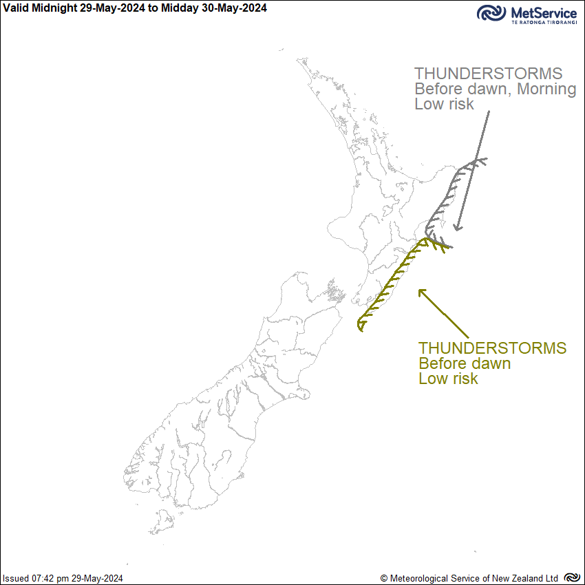
Issued at 9:05am 29/05/2024
Valid from Midnight 29/05/2024 to Midday 30/05/2024
The strong and unstable southwest flow over the North Island eases during Thursday morning. There is a low risk of thunderstorms before dawn for Wairarapa and the Tararua District, and for eastern parts of Hawke's Bay and Gisborne/Tairawhiti before dawn and during the morning. No other thunderstorms or significant convection expected over New Zealand during this period.
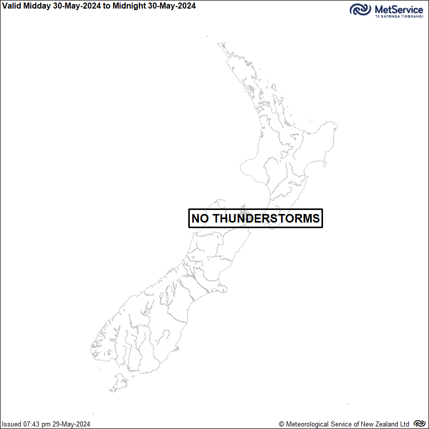
Issued at 8:55am 29/05/2024
Valid from Midday 30/05/2024 to Midnight 30/05/2024
No thunderstorms or significant convection expected during this period.
Severe Thunderstorm Criteria
In New Zealand, MetService classifies a thunderstorm as severe if one or more of the following criteria are met:
Heavy rain (from thunderstorms):
Rainfall of 25mm/h, or more.
Large hail:
Hailstones 20mm in diameter, or larger.
Strong wind gusts (from thunderstorms):
Gusts of 110km/h (60 knots) or stronger.
Damaging tornadoes:
Fujita F1 - i.e. wind speeds greater than 116km/h (63 knots) or stronger.
Note: some tornadic systems such as funnel clouds, waterspouts and small land-based tornadoes are possible with thunderstorms that may not be classified as severe.